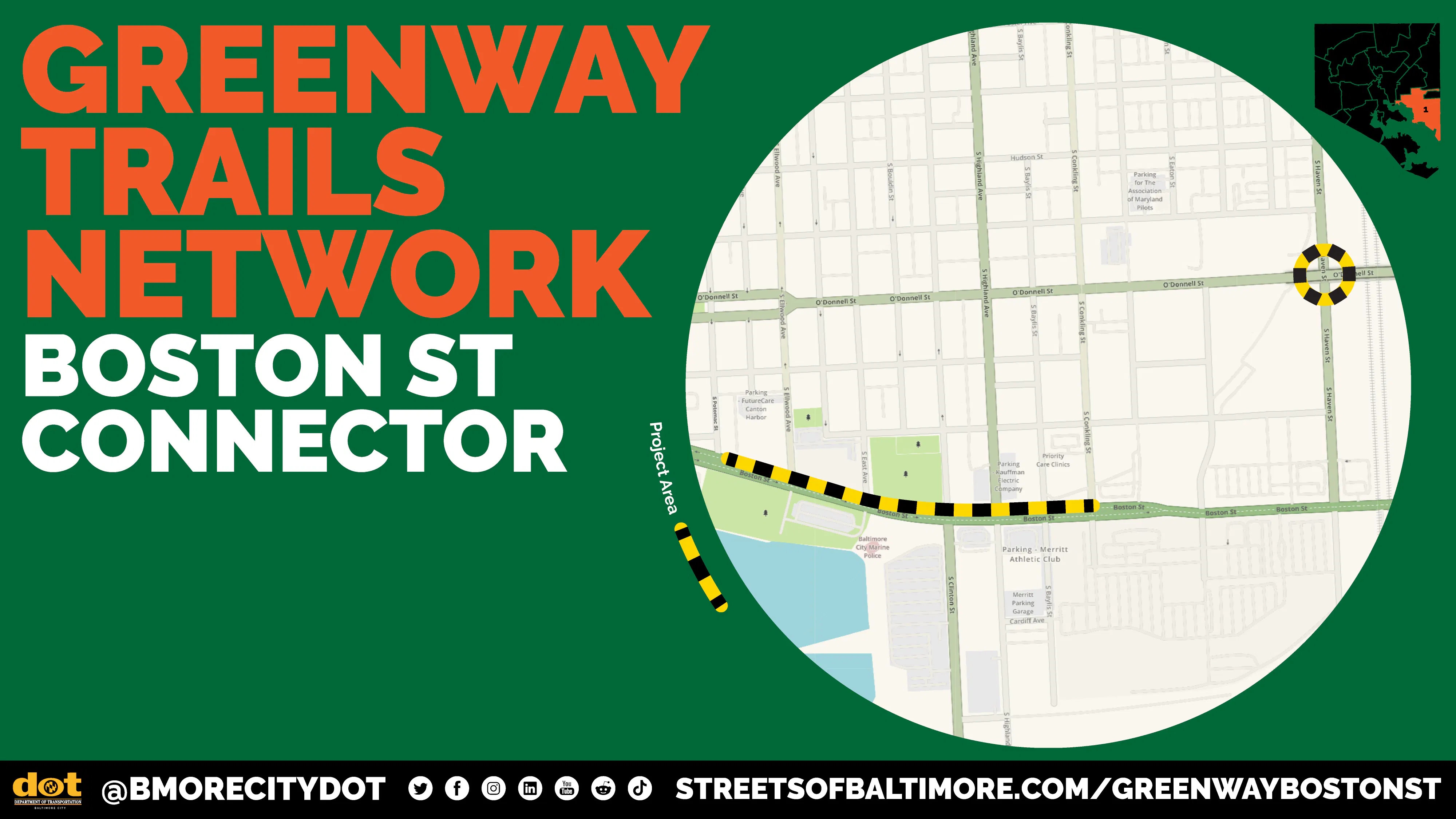
Greenway Trail Boston St Connector

Share Greenway Trail Boston St Connector on Facebook Share Greenway Trail Boston St Connector on X (formerly Twitter) Share Greenway Trail Boston St Connector on Linkedin Email Greenway Trail Boston St Connector link

About this Project

The Boston Street Connector Project is a planned 0.4-mile segment of the Baltimore Greenway Trail Network in the Canton neighborhood. This project would add a separated trail along the north side of Boston Street between Potomac Street Conkling Street, as well as a newly signalized intersection at S. Haven Street and O’Donnell Street. The project's eastern bound connects with trail segments built or planned by private developers between the Lucie Apartments and on Eaton Street.

This project is a part of the larger 73-mile Greenway Trails Network. Learn more about the network and how it connects Baltimore neighborhoods and makes our city a more livable and resilient place to live. Learn more about the network.


Project Goals

The Boston Street Connector Project seeks to:

  • Fill a crucial gap in the Greenway Trails Network. The project has been strategically planned to link together the Potomac Street protected cycle track (0.4 miles) and additional Greenway Trail segments along S. Haven Street as well as the planned Eastern Segments of the network northeast of Canton.

  • Increase multimodal access to key destinations. It will also provide a safe, reliable piece of Baltimore’s separated bike lane and trail network that can conveniently connect shoppers and workers to Canton Crossing, a popular retail and restaurant destination at the southeastern end of the Canton neighborhood.

  • Improve roadway safety. It aims to serve multimodal travelers in Southeast Baltimore who currently must share space with drivers on residential side streets north of Boston Street or the auto-oriented corridor of Boston Street.

Project Status

This project is in the Planning & Design phase.

As of Spring 2026, the Boston Street Connector is advancing from 30% design to the 100% design phase. Advancing the design to 100% will include:

  • Refining preliminary design plans prepared by BCDOT and partners

  • Re-engaging adjacent communities with project updates

  • Coordinating designs with the Red Line Project Team and other corridor stakeholders

Community Engagement

We will update this section when we have a schedule of planned engagement events. Please stay tuned!

About this Project

The Boston Street Connector Project is a planned 0.4-mile segment of the Baltimore Greenway Trail Network in the Canton neighborhood. This project would add a separated trail along the north side of Boston Street between Potomac Street Conkling Street, as well as a newly signalized intersection at S. Haven Street and O’Donnell Street. The project's eastern bound connects with trail segments built or planned by private developers between the Lucie Apartments and on Eaton Street.

This project is a part of the larger 73-mile Greenway Trails Network. Learn more about the network and how it connects Baltimore neighborhoods and makes our city a more livable and resilient place to live. Learn more about the network.


Project Goals

The Boston Street Connector Project seeks to:

  • Fill a crucial gap in the Greenway Trails Network. The project has been strategically planned to link together the Potomac Street protected cycle track (0.4 miles) and additional Greenway Trail segments along S. Haven Street as well as the planned Eastern Segments of the network northeast of Canton.

  • Increase multimodal access to key destinations. It will also provide a safe, reliable piece of Baltimore’s separated bike lane and trail network that can conveniently connect shoppers and workers to Canton Crossing, a popular retail and restaurant destination at the southeastern end of the Canton neighborhood.

  • Improve roadway safety. It aims to serve multimodal travelers in Southeast Baltimore who currently must share space with drivers on residential side streets north of Boston Street or the auto-oriented corridor of Boston Street.

Project Status

This project is in the Planning & Design phase.

As of Spring 2026, the Boston Street Connector is advancing from 30% design to the 100% design phase. Advancing the design to 100% will include:

  • Refining preliminary design plans prepared by BCDOT and partners

  • Re-engaging adjacent communities with project updates

  • Coordinating designs with the Red Line Project Team and other corridor stakeholders

Community Engagement

We will update this section when we have a schedule of planned engagement events. Please stay tuned!

Questions and Comments

Email
loader image
Didn't receive confirmation?
Seems like you are already registered, please provide the password. Forgot your password? Create a new one now.
  • Share Why was concrete chosen as the pavement for the proposed trail when flexible pavement is generally more desirable for cyclists due to the absence of pavement jointe? on Facebook Share Why was concrete chosen as the pavement for the proposed trail when flexible pavement is generally more desirable for cyclists due to the absence of pavement jointe? on X (formerly Twitter) Share Why was concrete chosen as the pavement for the proposed trail when flexible pavement is generally more desirable for cyclists due to the absence of pavement jointe? on Linkedin Email Why was concrete chosen as the pavement for the proposed trail when flexible pavement is generally more desirable for cyclists due to the absence of pavement jointe? link

    Why was concrete chosen as the pavement for the proposed trail when flexible pavement is generally more desirable for cyclists due to the absence of pavement jointe?

    R T asked about 1 month ago

    Thank you for your question. The materiality of the shared-use path is still being determined while preliminary design plans advance. We will share updated design plans when they become available.

  • Share Why does it stop at Ellwood Avenue if it has been “strategically planned” to link with the Potomac Avenue cycle track? What are you intending cyclists to do for the missing block between Ellwood and Potomac? on Facebook Share Why does it stop at Ellwood Avenue if it has been “strategically planned” to link with the Potomac Avenue cycle track? What are you intending cyclists to do for the missing block between Ellwood and Potomac? on X (formerly Twitter) Share Why does it stop at Ellwood Avenue if it has been “strategically planned” to link with the Potomac Avenue cycle track? What are you intending cyclists to do for the missing block between Ellwood and Potomac? on Linkedin Email Why does it stop at Ellwood Avenue if it has been “strategically planned” to link with the Potomac Avenue cycle track? What are you intending cyclists to do for the missing block between Ellwood and Potomac? link

    Why does it stop at Ellwood Avenue if it has been “strategically planned” to link with the Potomac Avenue cycle track? What are you intending cyclists to do for the missing block between Ellwood and Potomac?

    Bonk asked about 1 month ago

    Thank you for alerting us to this error in the geography on the GIS map. The segment has been updated to reflect the correct alignment beginning with the western bound at Potomac Street. We appreciate your engagement with BCDOT on this project!

Page published: 04 Jun 2026, 11:16 AM