Bush Street Cycle Track

Share Bush Street Cycle Track on Facebook Share Bush Street Cycle Track on X (formerly Twitter) Share Bush Street Cycle Track on Linkedin Email Bush Street Cycle Track link

About this Project

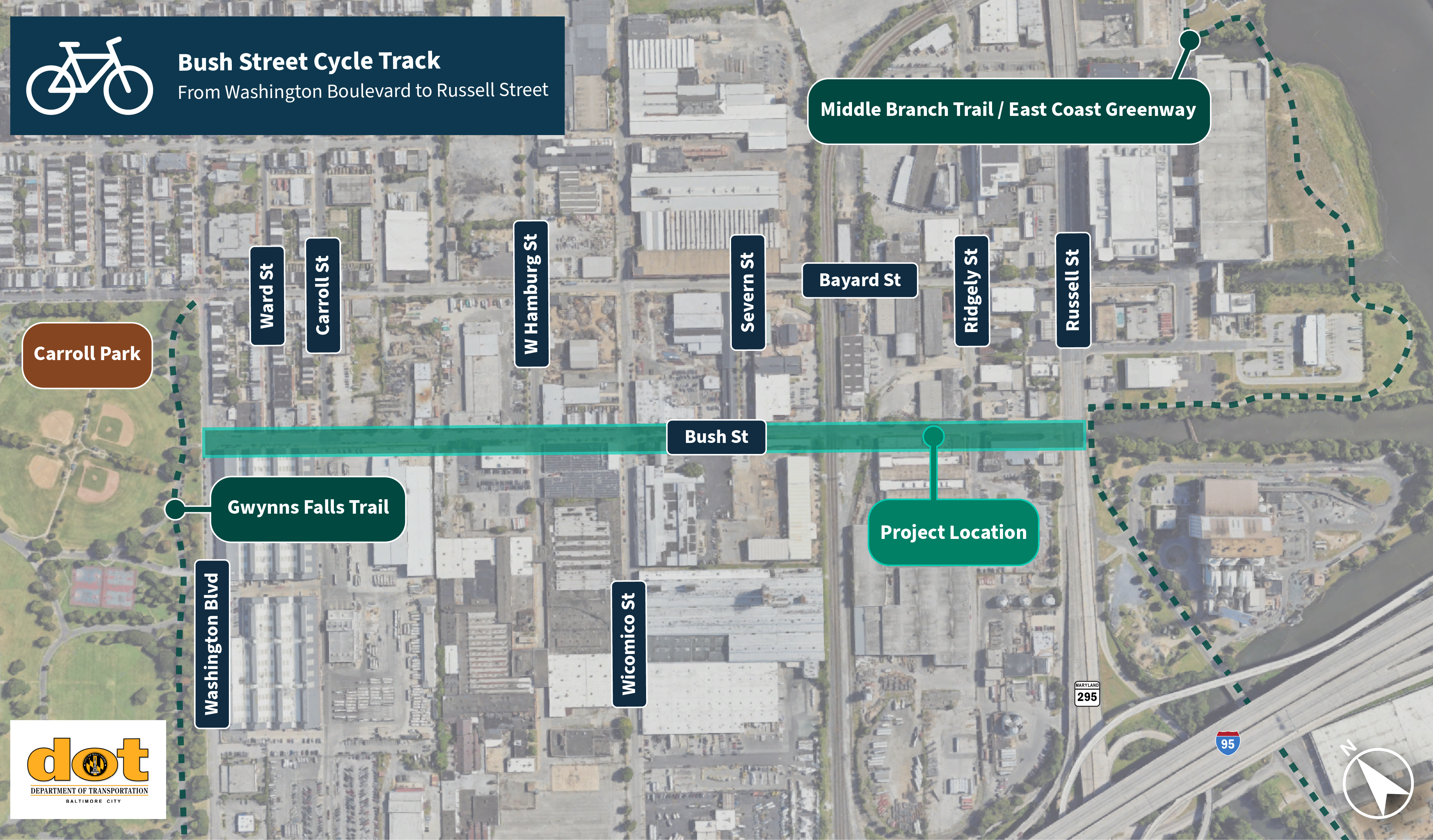
The Bush Street Cycle Track is a planned 0.6-mile protected multimodal facility in Southwest Baltimore that will connect segments of the Gwynns Falls Trail and Greenway Trails Network, including off-street trails in Carroll Park and along the Middle Branch of the Patapsco River. This project will utilize a roughly half-mile segment of Bush Street bounded by Washington Boulevard to the north and Russell Street to the south.

Greenway Trails Network is a vision for a 70+ mile trail system across Baltimore City that seeks to connect neighborhoods with natural resources and green space and make our city a more livable and resilient place to live. Learn more about the network.


Project Goals

The Bush Street Cycle Track seeks to:

  • Expand multimodal connections: This project will provide a new protected facility for non-drivers to travel safely and efficiently through an industrial corridor. With a relatively short alignment, the project will introduce a roadway design that replaces an unprotected, painted bicycle lane with a protected, all-ages facility.

  • Connect existing trail systems: The path system of Carroll Park is immediately north of the Middle Branch trail, located in the Horseshoe Casino and Entertainment District, but these two segments of the Gwynns Falls Trail are disconnected by a multilane, one-way road (Bush Street). The project will fill a glaring gap in the Greenway Trail system that will cater to non-drivers and anyone walking, rolling, or biking, in line with the City of Baltimore’s Complete Streets modal hierarchy

  • Introduce traffic calming: This project will create a dedicated, protected space on a roadway with an existing design that encourages cars to travel at high speeds, approaching a southern terminus at Russell Street with significant traffic and entertainment attractions, such as Horseshoe Casino and M&T Bank Stadium. The City of Baltimore is actively seeking to reduce crash rates and make travel conditions safer for drivers and non-drivers alike.
Project Status

This project is in the Planning Phase. As of Fall 2026, BCDOT is advancing existing 30% design plans to completion. The finalization of 100% designs will include:

  • Refining preliminary design plans (30% designs) prepared by BCDOT and partners

  • Re-engaging adjacent communities and other stakeholders

  • Completing construction-ready final designs (100% designs)

Community Engagement

We will update this section when we have a schedule of planned engagement events. Please stay tuned!

About this Project

The Bush Street Cycle Track is a planned 0.6-mile protected multimodal facility in Southwest Baltimore that will connect segments of the Gwynns Falls Trail and Greenway Trails Network, including off-street trails in Carroll Park and along the Middle Branch of the Patapsco River. This project will utilize a roughly half-mile segment of Bush Street bounded by Washington Boulevard to the north and Russell Street to the south.

Greenway Trails Network is a vision for a 70+ mile trail system across Baltimore City that seeks to connect neighborhoods with natural resources and green space and make our city a more livable and resilient place to live. Learn more about the network.


Project Goals

The Bush Street Cycle Track seeks to:

  • Expand multimodal connections: This project will provide a new protected facility for non-drivers to travel safely and efficiently through an industrial corridor. With a relatively short alignment, the project will introduce a roadway design that replaces an unprotected, painted bicycle lane with a protected, all-ages facility.

  • Connect existing trail systems: The path system of Carroll Park is immediately north of the Middle Branch trail, located in the Horseshoe Casino and Entertainment District, but these two segments of the Gwynns Falls Trail are disconnected by a multilane, one-way road (Bush Street). The project will fill a glaring gap in the Greenway Trail system that will cater to non-drivers and anyone walking, rolling, or biking, in line with the City of Baltimore’s Complete Streets modal hierarchy

  • Introduce traffic calming: This project will create a dedicated, protected space on a roadway with an existing design that encourages cars to travel at high speeds, approaching a southern terminus at Russell Street with significant traffic and entertainment attractions, such as Horseshoe Casino and M&T Bank Stadium. The City of Baltimore is actively seeking to reduce crash rates and make travel conditions safer for drivers and non-drivers alike.

Project Status

This project is in the Planning Phase. As of Fall 2026, BCDOT is advancing existing 30% design plans to completion. The finalization of 100% designs will include:

  • Refining preliminary design plans (30% designs) prepared by BCDOT and partners

  • Re-engaging adjacent communities and other stakeholders

  • Completing construction-ready final designs (100% designs)

Community Engagement

We will update this section when we have a schedule of planned engagement events. Please stay tuned!

Questions and Comments

You need to be signed in to add your question.

Page published: 26 Oct 2026, 01:46 AM