Toward Zero Quick Build Projects

Share Toward Zero Quick Build Projects on Facebook Share Toward Zero Quick Build Projects on X (formerly Twitter) Share Toward Zero Quick Build Projects on Linkedin Email Toward Zero Quick Build Projects link

Current Project Status

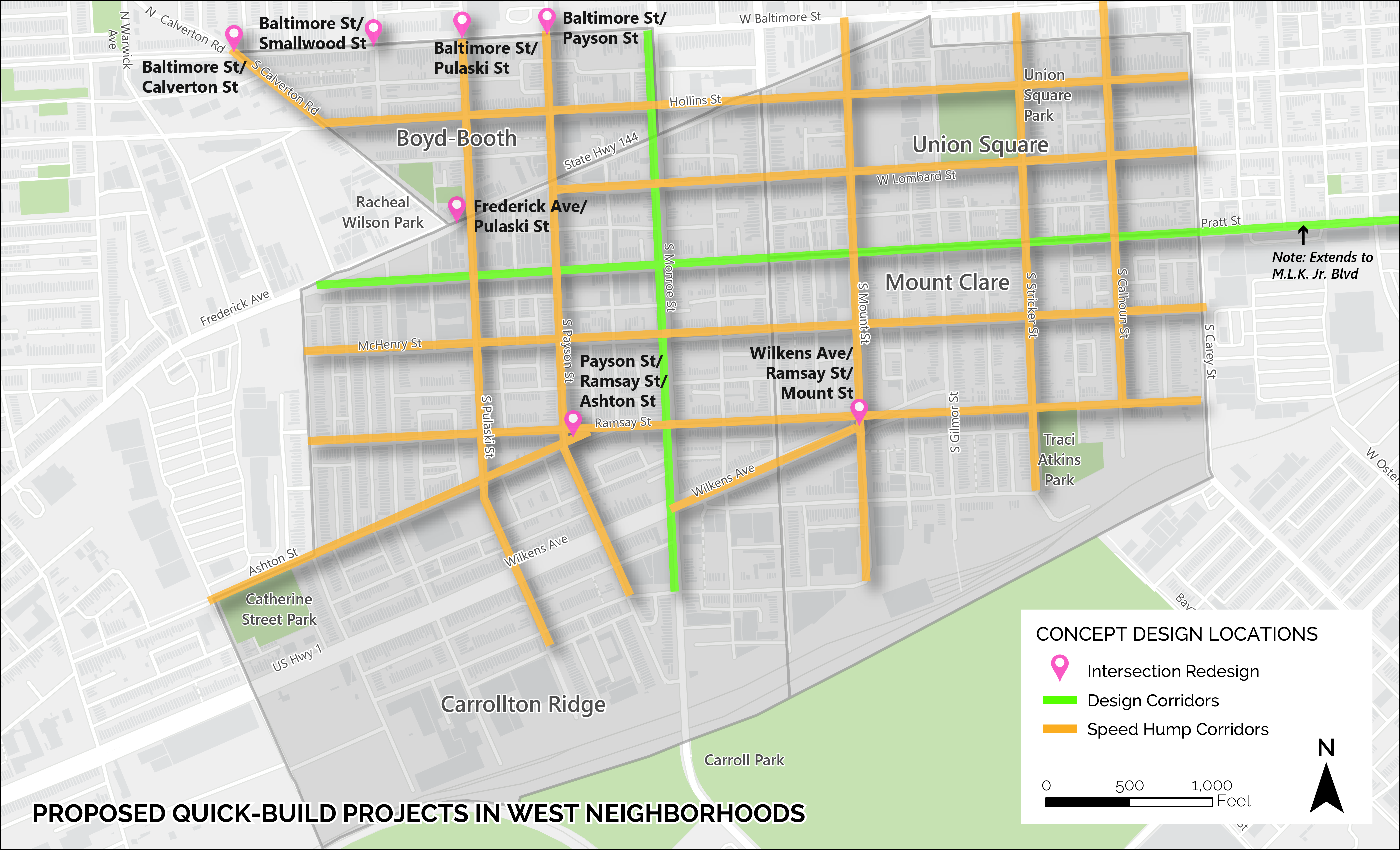
The Toward Zero project team has completed its existing conditions analysis of the eight selected neighborhoods and has selected priority locations for improvements. Selected corridors for quickbuild improvements include:

West:

  • Pratt Street, from Frederick Avenue to Martin Luther King Jr Boulevard
  • Monroe Street, from Baltimore Street to Eagle Street
  • Wilkens Avenue, Ramsay Street, and Mount Street intersection
  • Frederick Avenue and Pulaski Street intersection
  • Baltimore Street and Calverton, Smallwood, Pulaski, and Payson Street intersections
  • Ramsay, Ashton, and Payson intersection
East:

  • Fayette Street, from Luzerne Avenue to Kenwood Avenue
  • Jefferson Street, from Patterson Park Avenue to Highland Avenue
  • Madison Street, from Washington Street to Milton Avenue
  • Madison Street and Montford Avenue intersection
  • Fayette Street, Pulaski Highway, and Lakewood Avenue intersection


Corridor Designs

WEST PRATT STREET
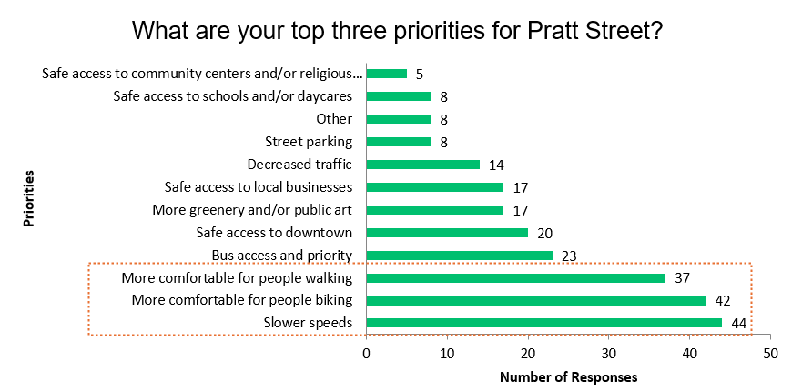

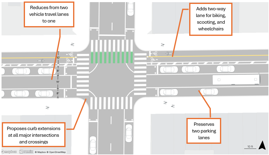
Proposed Design: The design for Pratt Street will extend from Frederick Avenue to MLK Blvd, offering traffic calming and multi-modal access benefits for all the neighborhoods along the corridor. Major elements include a parking-protected two-way cycletrack, removing one vehicle travel lane, and improving sight distance and visibility at the intersections. Curb extensions are added at all major intersections and crossings.

Safety benefits:

  • Reducing vehicle travel lanes from two to one prevents people from weaving between lanes and racing each other. This results in reduced vehicle speed and reduced conflict between vehicles. Reducing lanes also narrows the visual plane for drivers, psychologically constricting their available space which has proven slowing effects. According to the Federal Highway Administration, “road diets” can reduce crashes by 19 – 47%. The vehicle volume on Pratt Street is low enough to support this kind of treatment with no predicted traffic signal delay.
  • Shorter crossings for pedestrians reduce the exposure for people walking to motor vehicles.
  • The curb extensions at the intersections allow drivers and non-motorists to see oncoming traffic better.
  • Refreshed crosswalks make pedestrians more visible. Curb extensions also prevent drivers from cutting through their turn, slowing them down and improving their visibility of anyone crossing.
  • Separate travel facilities for bicyclists and scooters minimizes their interaction with motor vehicles, reducing conflicts. These facilities also give pedestrians and wheelchair users a safer space to move if there are obstructions on the sidewalk.
  • The northside cycletrack facility does not interfere with bus operations, allowing transit service to continue as is.
  • Bus stops will be pull-in in the short term. There is potential for bus bulbs as a longer-term solution, which will reduce bus delay.

EAST FAYETTE STREET
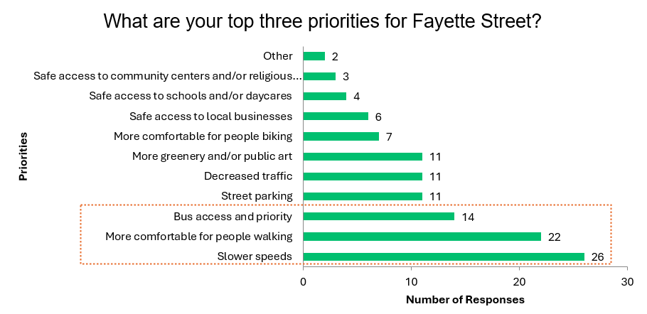
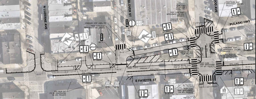
Proposed Design: The proposed design for Fayette Street aims to increase safety and comfort for people walking and taking the bus by increasing visibility at crosswalks, slowing turning speeds, reducing crossing distances, preventing opportunity for vehicle weaving and racing, narrowing vehicle travel lanes, and clarifying turning movements. The proposed configuration is two lanes of bidirectional vehicle travel, in-lane bus stops, and parking on either side of the street. Drivers on Pulaski would turn onto Fayette at Glover instead of merging between Glover and Luzerne. The design also preserves street parking and positions the parking in a way that calms traffic on Fayette. The Livable Streets Coalition in partnership with the Southest CDC is exploring ways of beautifying this design with art, planters, and other public amenities.


JEFFERSON STREET
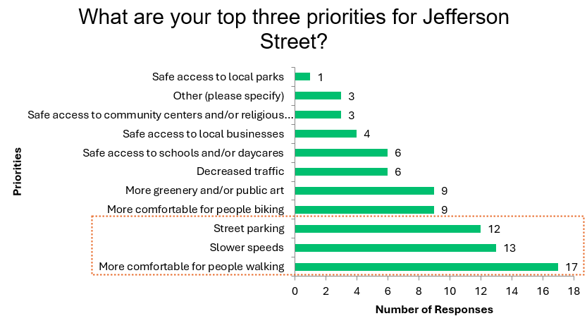
DOT is exploring a bike boulevard design for Jefferson Street, which preserves parking lanes and vehicle travel lanes, but may incorporate new speed humps, chicanes, medians, traffic circles, and other design elements to significantly slow traffic and pedestrianize the road.

--------------------------------------------------------------------------------------------------------------------------------------------------------------------------------------------------------

Each year, Toward Zero Baltimore will identify neighborhoods that have higher-than-average injury crash rates and strategize an array of quick-build traffic calming projects to improve safety and accessibility in those areas. To learn more about the Toward Zero initiative, visit our Towards Zero Program webpage.

Learn more about the current projects and share feedback on neighborhood safety concerns below

What are quick-build projects?

Quick-build refers to the process of using lower-cost, prefabricated structures to implement safer conditions more quickly at locations that need solutions now.

Quick-build projects are faster to implement because they do not require any modifications of structures in the Right-of-Way; this also makes these projects easy to remove or modify if they aren’t functioning as expected or if there is an opportunity to improve safety further.

Materials can include but are not limited to, signage, striping, flex-posts, and rubber curb-stops. Quick-build materials can be used to build any of the following proven traffic safety treatments:

Source: City of Lancaster
  • Daylighting
  • Curb bump-outs
  • Lane width reductions
  • Travel lane reductions
  • Bicycle infrastructure
  • Bus lanes
  • Chicanes
  • Angled parking
  • Speed limit reductions
  • Stop-controlled intersections
  • Crosswalks

In addition to quick-build treatments, we will also consider speed humps.

Current Projects

We used 2021 - 2023 crash data to identify "hot spots" or streets and intersections with high numbers of crashes resulting in injuries or fatalities. Considering equity and overlap with other planned projects, we then identified the following neighborhoods for systemic quick-build traffic calming improvements:

East Baltimore Neighborhoods

  • Ellwood Park
  • McElderry Park
  • Madison-Eastend
  • Milton-Montford

West Baltimore Neighborhoods

  • Boyd-Booth
  • Carrollton Ridge
  • Mount Clare
  • Union Square

The neighborhoods within each cluster are purposefully adjacent to each other to deliver systemic improvements. Selected locations are circled in yellow on the map:


Learn more about these projects below.


Ellwood Park, McElderry Park, Madison-Eastend, and Milton-Montford Safety Statistics

From 2020 to 2023, there were:

Fatal crashes occurred on Orleans Street, Monument Street, and Madison Street.

The intersections with the most crashes are Monument Street and Kenwood Avenue, Madison Street and Kenwood Avenue, and Orleans Street and Linwood Avenue.

Fatal and Injury Crashes 2020 - 2023

In the past three years, 311 requests for signs and signals have increased in the area.

There have been 100 requests for traffic calming, crosswalks, and pavement markings.

Many of the requests were on Orleans Street, McElderry Street, and Pulaski Highway.

311 Requests by Type 2022 - 2024 311 Requests 2022 - 2024

Boyd-Booth, Mount Clare, Carrollton Ridge, and Union Square Safety Statistics

From 2020 to 2023, there were:

Fatal crashes occurred on Lombard Street, Monroe Street, and Pratt Street.

The intersections with the most crashes include Wilkens Avenue and Fulton Street, Pratt Street and Monroe Street, and Pratt Street and Fulton Street.


Fatal and Injury Crashes 2020 - 2023.
In the past three years, 311 requests have increased in the area, especially requests for streetlights, signs, and signals.

There have been 65 requests for traffic calming, crosswalks, and markings.

Many of these requests were on Pratt Street and Wilkens Avenue.

311 Requests by Type 2022 - 2024
311 Requests 2022 - 2024

What’s Next?

DOT is currently doing outreach to get wide neighborhood participation around the proposed designs.

Past Events

Neighborhood safety walk audits:

  • 11/12/24 Boyd-Booth neighborhood walk, 11am – 1pm, Bon Secours Community Resource Center
  • 11/14/24 Mount Clare neighborhood walk, 3pm – 5pm, Wilkens Ave roundabout
  • 11/16/24 Eastside neighborhoods walk, 1pm – 4pm, Patterson Park Library
  • 12/13/24 Union Square neighborhood walk, 12:30 - 2pm, Lombard St and Stricker St
  • 12/16/24 Carrollton Ridge neighborhood walk, Samuel Morse Recreation Center

General project informational meetings:

  • 12/4/24 Livable Streets Coalition annual meeting, 6pm - 7:30pm
  • 1/25/25 City 4 All Forum, 10am - 2 pm, Johns Hopkins Hospital
  • 3/13/25 Transit Choices, 8:30 - 9:30am

Neighborhood existing conditions meetings:

  • 2/18/25 Carrollton Ridge MONSE meeting, 6:30 - 8pm, Samuel Fb Morse Recreation Center (424 S. Pulaski St.)
  • 2/19/25 Milton-Montford neighborhood meeting, 6 - 7pm, 901 N. Milton St.
  • 2/20/25 Ellwood Park Association meeting, 6:30 - 8pm, 2912 Pulaski Hwy
  • 2/27/25 Boyd-Booth meeting, 5 - 6pm, Bon Secours Community Resource Center
  • 2/27/25 Southwest Partnership Vibrant & Walkable Streets Committee meeting, 7 - 9pm, zoom link: https://swpbal.org/events/
  • 3/3/25 Union Square meeting, 7 - 9pm, 1401 Hollins St
  • 3/19/25 McElderry Park meeting, 6 - 8pm, 611 N Montford St

Community Transportation Priorities neighborhood meetings and pop-ups:

  • 4/27/25 Sunday Sounds in the Park, Union Square, 4 - 7pm
  • 4/29/25 Grace Medical ribbon cutting, Boyd-Booth, 2 - 4pm
  • 6/14/25 Ellwood Park Resource Fair, 10am - 2pm. Ellwood Avenue Park
  • 6/16/25 Carrollton Ridge community meeting, 6:30 - 8:30pm, Samuel Fb Morse Recreation Center (424 S. Pulaski St.)
  • 6/23/25 Mount Clare community meeting, 6 - 7pm, 355 S Woodyear St
  • 6/28/25 Clay Pots Community Day, 11am - 3pm, 1635 W Pratt St
  • 7/16/25 Milton-Montford community meeting, 6pm - 8pm, 901 N Milton Ave
  • 7/24/25 McElderry Park Block Party, 6pm - 9pm, Tench Tilghman Elementary/Middle School (600 N Patterson Park Ave)
  • 8/19/25 food giveaway at the Central Baptist Church in Boyd-Booth, 1pm - 4pm, 2031 W Baltimore St
  • 8/25/25 Union Square community association meeting, 7pm - 9pm, 1401 Hollins St
  • 10/16/25 food giveaway at the Food Project, 424 S Pulaski St, 9am - 12pm
  • 11/1/25 Replant the Library Square Mural Garden, 158 N Linwood Ave, 10am - 2pm
  • 11/20/25 Livable Streets Coalition meeting, Banner Neighborhoods, 2911 Pulaski Hwy, 6pm - 7:30pm

Design proposal meetings:

  • 2/21/26 Livable Streets Coalition meeting, Banner Neighborhoods, 10:30 - 12pm, 2706 Pulaski Highway (Fayette)
  • March - April 2026: NDC hosted a series of Zoom calls with key stakeholders (Fayette)
  • 3/23/26 William Paca School + Southeast CDC meeting (Fayette)
  • 4/8/26, Hollins Roundhouse, 7 - 9pm, virtual (Pratt)
  • 4/13/26 Patterson Park Community Association + Pulaski Highway residents, 6 - 7pm virtual (Fayette)
  • 5/12/26, Citizens of Pigtown, 7 - 8pm, virtual (Pratt)
  • 7/15/26 Milton-Montford community meeting, 6pm - 8pm, 901 N Milton Ave (Fayette, Madison)
  • 7/20/26 Carrollton Ridge community meeting, 6:30 - 8:30pm, Samuel Fb Morse Recreation Center (Pratt)
  • 7/27/26 Mount Clare community meeting, 6 - 7pm, 355 S Woodyear St (Pratt)


Add Your Input on our Community Maps!

Toward Zero Baltimore is our initiative to eliminate all fatalities and serious injuries on Baltimore City roadways.

The neighborhoods reflected on this map have some of the highest roadway injury rates in the City.

Please use these maps to tell us your experience on the roads and sidewalks in these neighborhoods. You can comment on existing 311 requests or log a new concern.

If you would like to contribute new information to an existing 311 concern, click the point on the map and then click the comment button. You can also like or dislike the 311 request.

If you would like to add a new concern to the map, select the "Log a Safety Concern" button, click "Community Information", and input the relevant information. It will then be added under the "Community Information" section for others to view and interact with.

Your input will help us identify vital safety interventions that will mitigate dangerous roadway behavior patterns.

West Baltimore

East Baltimore


Current Project Status

The Toward Zero project team has completed its existing conditions analysis of the eight selected neighborhoods and has selected priority locations for improvements. Selected corridors for quickbuild improvements include:

West:

  • Pratt Street, from Frederick Avenue to Martin Luther King Jr Boulevard
  • Monroe Street, from Baltimore Street to Eagle Street
  • Wilkens Avenue, Ramsay Street, and Mount Street intersection
  • Frederick Avenue and Pulaski Street intersection
  • Baltimore Street and Calverton, Smallwood, Pulaski, and Payson Street intersections
  • Ramsay, Ashton, and Payson intersection

East:

  • Fayette Street, from Luzerne Avenue to Kenwood Avenue
  • Jefferson Street, from Patterson Park Avenue to Highland Avenue
  • Madison Street, from Washington Street to Milton Avenue
  • Madison Street and Montford Avenue intersection
  • Fayette Street, Pulaski Highway, and Lakewood Avenue intersection


Corridor Designs

WEST PRATT STREET


Proposed Design: The design for Pratt Street will extend from Frederick Avenue to MLK Blvd, offering traffic calming and multi-modal access benefits for all the neighborhoods along the corridor. Major elements include a parking-protected two-way cycletrack, removing one vehicle travel lane, and improving sight distance and visibility at the intersections. Curb extensions are added at all major intersections and crossings.


Safety benefits:

  • Reducing vehicle travel lanes from two to one prevents people from weaving between lanes and racing each other. This results in reduced vehicle speed and reduced conflict between vehicles. Reducing lanes also narrows the visual plane for drivers, psychologically constricting their available space which has proven slowing effects. According to the Federal Highway Administration, “road diets” can reduce crashes by 19 – 47%. The vehicle volume on Pratt Street is low enough to support this kind of treatment with no predicted traffic signal delay.
  • Shorter crossings for pedestrians reduce the exposure for people walking to motor vehicles.
  • The curb extensions at the intersections allow drivers and non-motorists to see oncoming traffic better.
  • Refreshed crosswalks make pedestrians more visible. Curb extensions also prevent drivers from cutting through their turn, slowing them down and improving their visibility of anyone crossing.
  • Separate travel facilities for bicyclists and scooters minimizes their interaction with motor vehicles, reducing conflicts. These facilities also give pedestrians and wheelchair users a safer space to move if there are obstructions on the sidewalk.
  • The northside cycletrack facility does not interfere with bus operations, allowing transit service to continue as is.
  • Bus stops will be pull-in in the short term. There is potential for bus bulbs as a longer-term solution, which will reduce bus delay.

EAST FAYETTE STREET

Proposed Design: The proposed design for Fayette Street aims to increase safety and comfort for people walking and taking the bus by increasing visibility at crosswalks, slowing turning speeds, reducing crossing distances, preventing opportunity for vehicle weaving and racing, narrowing vehicle travel lanes, and clarifying turning movements. The proposed configuration is two lanes of bidirectional vehicle travel, in-lane bus stops, and parking on either side of the street. Drivers on Pulaski would turn onto Fayette at Glover instead of merging between Glover and Luzerne. The design also preserves street parking and positions the parking in a way that calms traffic on Fayette. The Livable Streets Coalition in partnership with the Southest CDC is exploring ways of beautifying this design with art, planters, and other public amenities.


JEFFERSON STREET

DOT is exploring a bike boulevard design for Jefferson Street, which preserves parking lanes and vehicle travel lanes, but may incorporate new speed humps, chicanes, medians, traffic circles, and other design elements to significantly slow traffic and pedestrianize the road.

--------------------------------------------------------------------------------------------------------------------------------------------------------------------------------------------------------

Each year, Toward Zero Baltimore will identify neighborhoods that have higher-than-average injury crash rates and strategize an array of quick-build traffic calming projects to improve safety and accessibility in those areas. To learn more about the Toward Zero initiative, visit our Towards Zero Program webpage.

Learn more about the current projects and share feedback on neighborhood safety concerns below

What are quick-build projects?

Quick-build refers to the process of using lower-cost, prefabricated structures to implement safer conditions more quickly at locations that need solutions now.

Quick-build projects are faster to implement because they do not require any modifications of structures in the Right-of-Way; this also makes these projects easy to remove or modify if they aren’t functioning as expected or if there is an opportunity to improve safety further.

Materials can include but are not limited to, signage, striping, flex-posts, and rubber curb-stops. Quick-build materials can be used to build any of the following proven traffic safety treatments:

Source: City of Lancaster
  • Daylighting
  • Curb bump-outs
  • Lane width reductions
  • Travel lane reductions
  • Bicycle infrastructure
  • Bus lanes
  • Chicanes
  • Angled parking
  • Speed limit reductions
  • Stop-controlled intersections
  • Crosswalks

In addition to quick-build treatments, we will also consider speed humps.

Current Projects

We used 2021 - 2023 crash data to identify "hot spots" or streets and intersections with high numbers of crashes resulting in injuries or fatalities. Considering equity and overlap with other planned projects, we then identified the following neighborhoods for systemic quick-build traffic calming improvements:

East Baltimore Neighborhoods

  • Ellwood Park
  • McElderry Park
  • Madison-Eastend
  • Milton-Montford

West Baltimore Neighborhoods

  • Boyd-Booth
  • Carrollton Ridge
  • Mount Clare
  • Union Square

The neighborhoods within each cluster are purposefully adjacent to each other to deliver systemic improvements. Selected locations are circled in yellow on the map:


Learn more about these projects below.


Ellwood Park, McElderry Park, Madison-Eastend, and Milton-Montford Safety Statistics

From 2020 to 2023, there were:

Fatal crashes occurred on Orleans Street, Monument Street, and Madison Street.

The intersections with the most crashes are Monument Street and Kenwood Avenue, Madison Street and Kenwood Avenue, and Orleans Street and Linwood Avenue.

Fatal and Injury Crashes 2020 - 2023

In the past three years, 311 requests for signs and signals have increased in the area.

There have been 100 requests for traffic calming, crosswalks, and pavement markings.

Many of the requests were on Orleans Street, McElderry Street, and Pulaski Highway.

311 Requests by Type 2022 - 2024 311 Requests 2022 - 2024

Boyd-Booth, Mount Clare, Carrollton Ridge, and Union Square Safety Statistics

From 2020 to 2023, there were:

Fatal crashes occurred on Lombard Street, Monroe Street, and Pratt Street.

The intersections with the most crashes include Wilkens Avenue and Fulton Street, Pratt Street and Monroe Street, and Pratt Street and Fulton Street.


Fatal and Injury Crashes 2020 - 2023.
In the past three years, 311 requests have increased in the area, especially requests for streetlights, signs, and signals.

There have been 65 requests for traffic calming, crosswalks, and markings.

Many of these requests were on Pratt Street and Wilkens Avenue.

311 Requests by Type 2022 - 2024
311 Requests 2022 - 2024

What’s Next?

DOT is currently doing outreach to get wide neighborhood participation around the proposed designs.

Past Events

Neighborhood safety walk audits:

  • 11/12/24 Boyd-Booth neighborhood walk, 11am – 1pm, Bon Secours Community Resource Center
  • 11/14/24 Mount Clare neighborhood walk, 3pm – 5pm, Wilkens Ave roundabout
  • 11/16/24 Eastside neighborhoods walk, 1pm – 4pm, Patterson Park Library
  • 12/13/24 Union Square neighborhood walk, 12:30 - 2pm, Lombard St and Stricker St
  • 12/16/24 Carrollton Ridge neighborhood walk, Samuel Morse Recreation Center

General project informational meetings:

  • 12/4/24 Livable Streets Coalition annual meeting, 6pm - 7:30pm
  • 1/25/25 City 4 All Forum, 10am - 2 pm, Johns Hopkins Hospital
  • 3/13/25 Transit Choices, 8:30 - 9:30am

Neighborhood existing conditions meetings:

  • 2/18/25 Carrollton Ridge MONSE meeting, 6:30 - 8pm, Samuel Fb Morse Recreation Center (424 S. Pulaski St.)
  • 2/19/25 Milton-Montford neighborhood meeting, 6 - 7pm, 901 N. Milton St.
  • 2/20/25 Ellwood Park Association meeting, 6:30 - 8pm, 2912 Pulaski Hwy
  • 2/27/25 Boyd-Booth meeting, 5 - 6pm, Bon Secours Community Resource Center
  • 2/27/25 Southwest Partnership Vibrant & Walkable Streets Committee meeting, 7 - 9pm, zoom link: https://swpbal.org/events/
  • 3/3/25 Union Square meeting, 7 - 9pm, 1401 Hollins St
  • 3/19/25 McElderry Park meeting, 6 - 8pm, 611 N Montford St

Community Transportation Priorities neighborhood meetings and pop-ups:

  • 4/27/25 Sunday Sounds in the Park, Union Square, 4 - 7pm
  • 4/29/25 Grace Medical ribbon cutting, Boyd-Booth, 2 - 4pm
  • 6/14/25 Ellwood Park Resource Fair, 10am - 2pm. Ellwood Avenue Park
  • 6/16/25 Carrollton Ridge community meeting, 6:30 - 8:30pm, Samuel Fb Morse Recreation Center (424 S. Pulaski St.)
  • 6/23/25 Mount Clare community meeting, 6 - 7pm, 355 S Woodyear St
  • 6/28/25 Clay Pots Community Day, 11am - 3pm, 1635 W Pratt St
  • 7/16/25 Milton-Montford community meeting, 6pm - 8pm, 901 N Milton Ave
  • 7/24/25 McElderry Park Block Party, 6pm - 9pm, Tench Tilghman Elementary/Middle School (600 N Patterson Park Ave)
  • 8/19/25 food giveaway at the Central Baptist Church in Boyd-Booth, 1pm - 4pm, 2031 W Baltimore St
  • 8/25/25 Union Square community association meeting, 7pm - 9pm, 1401 Hollins St
  • 10/16/25 food giveaway at the Food Project, 424 S Pulaski St, 9am - 12pm
  • 11/1/25 Replant the Library Square Mural Garden, 158 N Linwood Ave, 10am - 2pm
  • 11/20/25 Livable Streets Coalition meeting, Banner Neighborhoods, 2911 Pulaski Hwy, 6pm - 7:30pm

Design proposal meetings:

  • 2/21/26 Livable Streets Coalition meeting, Banner Neighborhoods, 10:30 - 12pm, 2706 Pulaski Highway (Fayette)
  • March - April 2026: NDC hosted a series of Zoom calls with key stakeholders (Fayette)
  • 3/23/26 William Paca School + Southeast CDC meeting (Fayette)
  • 4/8/26, Hollins Roundhouse, 7 - 9pm, virtual (Pratt)
  • 4/13/26 Patterson Park Community Association + Pulaski Highway residents, 6 - 7pm virtual (Fayette)
  • 5/12/26, Citizens of Pigtown, 7 - 8pm, virtual (Pratt)
  • 7/15/26 Milton-Montford community meeting, 6pm - 8pm, 901 N Milton Ave (Fayette, Madison)
  • 7/20/26 Carrollton Ridge community meeting, 6:30 - 8:30pm, Samuel Fb Morse Recreation Center (Pratt)
  • 7/27/26 Mount Clare community meeting, 6 - 7pm, 355 S Woodyear St (Pratt)


Add Your Input on our Community Maps!

Toward Zero Baltimore is our initiative to eliminate all fatalities and serious injuries on Baltimore City roadways.

The neighborhoods reflected on this map have some of the highest roadway injury rates in the City.

Please use these maps to tell us your experience on the roads and sidewalks in these neighborhoods. You can comment on existing 311 requests or log a new concern.

If you would like to contribute new information to an existing 311 concern, click the point on the map and then click the comment button. You can also like or dislike the 311 request.

If you would like to add a new concern to the map, select the "Log a Safety Concern" button, click "Community Information", and input the relevant information. It will then be added under the "Community Information" section for others to view and interact with.

Your input will help us identify vital safety interventions that will mitigate dangerous roadway behavior patterns.

West Baltimore

East Baltimore


Page last updated: 24 Jul 2026, 10:58 AM